


Chaminda Bandara Ambanwala
Department of Archaeology & Heritage Management, Rajarata University of Sri Lanka, Mhintale.
Translated by : Chryshane Mendis
Archaeology is considered a multidisciplinary and interdisciplinary subject. It could be said so as the knowledge generated from other natural sciences and social sciences are used to get an overview of archaeology. When studying about the prehistoric man under archaeology, just as looking into the cultural features, the Archaeologist should also look into the environmental features around. Although the prehistoric man built a culture, as he too is an animal who depends on the environment and the culture he built is also based on environmental facts, the natural environment therefore, is important.  In the study of prehistoric man, the Archaeologist cannot get a total understanding of him by studying the cultural factors alone. Attention should be focused on the environmental factors as well. This article series which attempts to follow the story of the prehistoric man of Sri Lanka will try to give a brief understanding of the environment in which he lived or rather from which he lived in. Therefore let us take a look into the ancient environment or the geographical and geological factors of Sri Lanka.
The placement of Sri Lanka
Sri Lanka is separated from the Indian subcontinent by a 29 km wide strip of sea and is 8┬░ north of the equator. The absolute location of Sri Lanka is situated between Northern latitude 50 55ÔÇØ ÔÇô 90 51ÔÇÖ and East longitude 790 41ÔÇØ ÔÇô 810 53ÔÇØ

Delft, Punkuduthiv, and Analathiv are some of the many islands separate of the mainland found in the north and north west. From Point Pedro in the North to Dondra head in the south is 430 km in length and from Point Sangamankanda in Kalmune in the East to Colombo in the West is 227 km at its maximum width. Total square area of Sri Lanka is 65,610 square km. To the south-west of the country are the Maldivian islands, and to the south-east, the Nicobar and Andaman islands. The islandÔÇÖs terrain, weather, climate, flora and fauna, soil and other data show a relationship to nearby southern India.
The Geological history of Sri Lanka
As one of the founders of geological research in Sri Lanka, the Indian national D.N. Wadia has stated that the geological history of Sri Lanka is still not 100% known. But an overview of the geological history of Sri Lanka can be viewed by the studies conducted so far. Sri LankaÔÇÖs geological scale goes back as far as to the ancient super-continent of Gondwanaland described by Alfred Wegener. Much of Sri Lanka comprises of Precambrian rock as old as 280 million years. Accordingly, the landmass of Sri Lanka has suffered all the changes faced by the planet over millions of years.
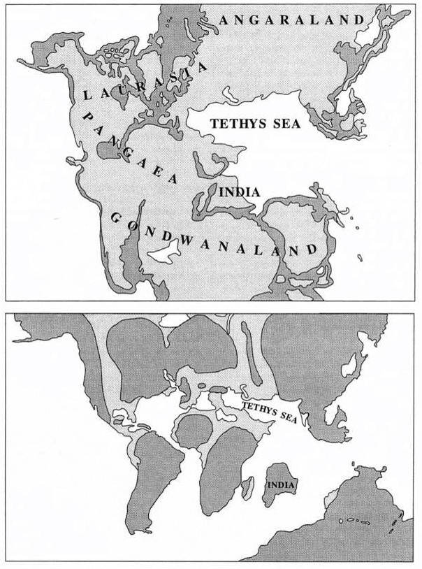
From the beginning of geological activities, the landmass south of the Himalayas mountain range which is India, Pakistan, Afganistan and Sri Lanka were an island. At that time the area of Sri Lanka was situated around 7┬░ north of the equator. Later all the landmass on the surface of the earth formed into the large super continent known as Pangaea and the landmass of the Indian subcontinent passing the equator joined the continents of Africa and Antarctica.
26 million years ago during the Permian period, the south of Sri Lanka was joined with South Africa and western Antarctica and settled in a snow covered area 60 latitudes south. As a result of the rising temperature during this period, a glacier flowing from South Africa drifted over southern Sri Lanka creating several geological features. During the historical period, an important aspect of the hydraulic culture was the construction of tanks, the depression in the land which aided its construction is considered to have been generated through the erosion of such glaciers.  The gold and gem stones found in certain lake basins are believed to have been washed down from the gold and diamond sites in Africa by the glaciers and being deposited here.
After the super-continent Pangaea broke off into sections, the landmass of Gondwanaland too broke off and the continent of Australia and the Indian subcontinent began their northwards journey.  18 million years ago in the Jurassic period, the island moved to the tropical climate and thus coniferous plant fossils have been recorded from the Vanni region and the northwestern area of the island in Thabbowa and Adigama.
6.5 million Years ago the Indian subcontinent moving northwards collided with the Eurasian continent and as a result of this collision the Himalayan mountain range was formed. It is evident that this northward push of the subcontinent is still in progress as observations have shown that the Himalayas continue to rise few centimetres a year. Due to this collision, the island of Sri Lanka began its separation from the mainland and continues to move 1 centimetre a year towards the south-west. As a result of this, the peninsula of Jaffna which was once part of the Madurai area of India is now around 325 km southwards.
During the glacial and inter-glacial periods throughout the world, the sea levels rose and fell and as a result, Sri Lanka and India were separated and joined again several times. With this, the land bridge formed between India and Sri Lanka gave the needed backing for the movement of species between the two landmasses. This on and off separation continued for several hundred thousand years and was completely separated for the last time around 7,000 years ago. During the times when the sea levels rose, a limestone layer was formed on the coral reefs in the Palk Strait. Accordingly 2.4 million years ago during the Miocene epoch of the Tertiary period which is believed to be a warm period, due to the flooding of land by sea water the Limestone sediments from Jaffna to Puttalam were formed. During this time scholars assume the northwestern coast of the Island to have been along Puttalam, Madu Church and across Mankulam to Mulathivu.
2 million years ago the Pleistocene epoch of the Quaternary period saw the flourishing of animal and plant life at a respectable level. Through an archaeological dig in the Alluvial soil deposits from Rathnapura several years ago by Dr.P.E.P. Deraniyagala many remains of extinct and living species of animals were found. He pointed out that these species showed a close connection with the species of the Siwalik and Narbada regions of India. This series will discuss further on the history of the Pleistocene epoch in Sri Lanka in another article.
It is the view of geologists that there is few evidence of the islandÔÇÖs geological history from the Precambrian eon to the Jurassic period. ┬áThe lack of major evidence from these periods suggests that during this time the entire land was one stable landmass. The rock formations throughout the country like Mihinthalaya, Sigiriya, Dimbulagala, and Dolukanda provide examples for this.
The Birth of Sri LankaÔÇÖs landscape
The origins of the islandÔÇÖs landscape was the subject of geologists from the beginning of the 20th century, firstly by foreign scholars and then by the local scholars. Collecting all ideas on the birth of the landscape Prof. C.M. Madduma Bandara on an article tiled ÔÇ£the geological background of the MahawaliÔÇØ to the Mahawali Wansha Granthaya explains this perfectly. The following is taken from that article and all due credit should go to him.
The first view of the birth of the landscape of Sri Lanka was given in 1928 by the Scandinavian geologist F. D. Adams terming it the ÔÇ£En-mass block upliftÔÇØ. By drawing a cross section of the landscape from north to south and east west he identified 3 different plains varying in height. He has shown that these 3 different plains could be witnessed along the Haputale-Haldumulla road. He pointed out that these plains contain at times rapid slops and at times escarpments giving the ÔÇÿWorlds endÔÇÖ as an example. According to Adams similar to the highest plains, a large landmass first became land through the Block uplift. This first land was quite higher than the present highest level. After weathering for a long period the second uplift took place lifting this block and raising both these blocks the third uplift took place. This third block, Adams believes is similar to the present landmass of Sri Lanka. According to this view, the central hills should show the oldest features of the land but scholars point out that the highest slopes of the hills show the youngest features.

As an alternative view, D.N. Wadia, the Indian geologist put forward the ÔÇ£Circumscribe Block UpliftÔÇØ theory in 1943. According to this theory, a landmass similar to the entire island faced an uplift and complementary block uplifts which took place in the center gave the present landscape its features. As of this view, the oldest sections are the coastal regions. The faults along the Nilgiri mountains of India, the Malabar coast, and Thabbowa are believed to be during the period of the Circumscribe Block Uplift. Further the Sri Lankan geologist K. Kularathnam proposed another theory called the ÔÇ£Multiple Block UpliftÔÇØ theory in 1953.
A theory based on Geo-movement was put forward in 1972 by D. P. W. Withanage. According to him, the land of the central highlands developed through micro Geo-movement and with the process of erosion gave birth to its present form.
Many such theories on the origin of the landscape of the island have been put forward and its origin is continued to be studied by geologists at present. The geological evidence found have played an important role in determining the origin of the landscape and it could be seen that these factors have in later times aided the development of human civilization. In a simple way, this fact could be seen as how the geological features have influenced the survival of the prehistoric man and his culture.
Sri LankaÔÇÖs geological zones
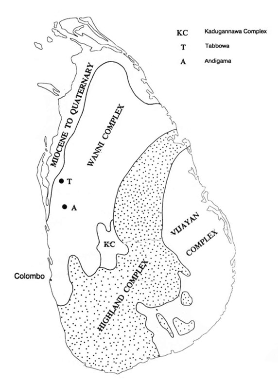
Geologically looking, 9/10 of Sri Lanka comprises of highly crystalline rocks of more than 570 million years ago from the Precambrian era. The rest 1/10 comprises of sedimentary formations such as limestone, sands and clay of the Jurassic period and tertiary and quaternary periods. In the northern zone, a layer of limestone formed during the Miocene epoch could be traced. Precambrian rocks could be divided into 4 main categories based on their rock types, isotopic characteristics and structures.
- Highland complex: the central highlands and northeast and south-west of the island.
- Wanni complex: also called the Western Vijayan complex, comprises of the lowlands west of the Highland complex.
- Vijayan complex: also called the Eastern Vijanyan complex, consists of the land east of the Highland complex.
- Kadugannawa complex: centrally located in the Highland complex, the internal rocks are separate to that of the Highland complex.
Sri LankaÔÇÖs geographical background
Temperature
Due to Sri Lanka being an equatorial country, it receives direct sun light throughout the year. Although there is a consistent temperature throughout the year it is hard to see a distinct division. Even though itÔÇÖs hard to get a clear temperature difference in Sri Lanka, the normal monthly medium temperature is 27.4 ┬░C and annual medium temperature is less than 27.8 ┬░C. When traveling from sea level upwards the temperature drops around 0.64 ┬░C for every 100 meters. Under these temperature conditions, it is favorable for human habitation and does not affect human settlements. Hence just as many other environmental factors, the temperature of the island too provides favorable living conditions.
Rainfall
Rain is the main method by which Sri Lanka receives freshwater, an important component for life. According to annual rainfall data, the highest rainfall is recorded from the central hills while the western region receives the most rainfall. Sri Lanka receives rain in 3 ways, 1) by Convectional rain, 2) by Monsoonal rain, 3) by Cyclonic rain. Due to the cyclonic conditions in the Bay of Bengal Sri Lanka receives cyclonic rain between the months of October to November with heavy rainfall to North and East. Based on these facts it is clear that due to the consistent rainfall there is sufficient freshwater for animals. On the other hand the many water ways which flow from the central hills creates a favorable condition for human civilization. The rain, streams, springs, and other water bodies all aid greatly in the survival of Man. When studying the ancient human habitats and other elements of prehistoric man it is clear that the habitat of the ancient man was always close to a water source.
Soil distribution
When studying the natural environment of prehistoric man, an important component which helped his activities is the soil. A habitable environment for animal and plant life is only made possible by a stable soil. Looking in comparison to rock materials, there are few features of soil.
- Animals and plants that live on the soil
- Having a structure in the soil
- Ability to withstand environmental changes
Soil also plays an important role in an archaeological study by protecting the animal and plant remains found in the different types of soil and sediment and thus providing a valuable insight into the ancient environment. Examining certain types of soil provides us with vital information on Man. Physical and chemical weathering of the bedrock helps in the creation of soil and given below are some of the main factors that help in this process:
- Climate
- Parent materials
- Relief
- Organisms
- Time
The Dry zone and Semi dry Intermediate zone, the Wet zone and Semi wet Intermediate zone are the different climatic zones of Sri Lanka and out of the identified 25 types of soil found within these zones, they fall under the 14 great soil groups. This differentiation depends on the variance of the factors and the parent rock. Out of the soil distribution of the island, the red soil found from the coastal regions of north-west and south-east Sri Lanka has revealed rich evidence relating to the prehistory of the Island. Scholars point out that this soil has been formed due to special climatic conditions. But wrong views about this soil are found spreading in the society at present. At present, the oldest human artifacts have been found from this soil and the information from these sheds light on the Paleolithic period.
Natural Flora
Any place where flora has been generated without the intervention of Man is known as Natural flora. Sri LankaÔÇÖs flora is divided into two main parts, 1) Forests and 2) Grasslands. Archaeologists believe that this natural flora directly influenced the behavior of prehistoric man and the related cultural elements. Some grasslands and plains of the central highlands are the results of the work of prehistoric man as Dr. Siran Deraniyagala has shown.
Environmental zones
Depending on many environmental factors researchers have been able to divide Sri LankaÔÇÖs environment into several zones. They are divided according to the below diagram.
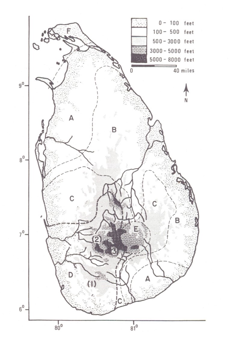
For archaeological investigations at present, these divisions are used. Accordingly, when planning prehistoric expeditions and the interpretation of human components, various zones are classified based on these environmental zones. Out of the archaeological studies on prehistoric man carried out so far, the majority of studies have been from the wet zone or ÔÇÿEnvironmental zone DÔÇÖ and some from the semi-arid zone or ÔÇÿEnvironmental zone AÔÇÖ. Studies from the semi-arid zone have revealed some of the oldest prehistoric evidences dating to the Paleolithic period while studies from caves of the wet zone mostly dates to the Mesolithic period. The other zones have seen less attention on the study prehistoric man and should be the areas of study in the future.
Another good article. Thanks.
Thank you.
Another enjoyable article in Sri Lankan archaeology, a subject area that is, sadly, very lacking in authentic and authoritative popular communications of the work being done. I cannot compliment further until I know how much of this article was structured by the original scholar and how much was the sctructuring done by the translator who, himself, is building a reputation in professional archaeological journalism.
COMMENT: In terms of ‘popular’ communications, I feel that this article is not structured adequately for MASS level consumption. However, with just a little more editing, the article could be accessible to an intermediate audience of intellectuals (non-scholar-archaeologist) interested in archaeology (like myself). There is a substantial audience at this level as well and, the translator/journalist should work to build his audience at this level (intellectuals). However, he should also strive to do editing work to reach the ‘popular’ or mass audience both in Sinhala and Tamil. Genuine, archaeology-based popular historiography is seriously lacking in this country and this lack is a major contributor to the current cultural mindsets that are then manipulated to mobilise a myth-based ethno-nationalism that is the primary driver of the destructive ethnic conflict. Thus, those scholars who enable their work to be brought to popular audiences by professional journalists such as Chryshane will be doing a significant service to their country (rarely done so directly by most of their discipline in other parts of the world). As a veteran journalist/editor, I am happy to help, not so much in direct writing (no time) but in guiding the design of articles to accurately meet different types of audiences both here and internationally.
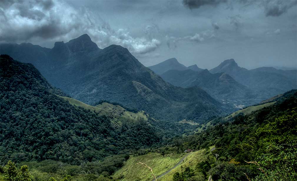
ALSO: that photograph of a part of the Knuckles range: at first glance, even before seeing the caption, from the topography, I guessed it was the Knuckles range. 🙂 But what is lacking in the caption is the naming of the valley so that Sri Lankans (who know of the Knuckles in general) would learn more the different parts of this substantial and distinctive (and beautiful) zone of the country. Again, this lack of knowledge of details about our island also contributes to the ideological simplifications so useful for modern obscurantist myth-building which, sadly, has been so destructive. If the scholar author could give us the name of this meandering river valley – inserted in the caption? I loved the picture!
Thank very much for your comments. We will try our best to overcome the issues you highlighted by you. Thank you for volunteering to guide us. We are eager to learn from a senior journalist like you. We will contact you.
Yes, the dramatic Knuckles photo captured this viewer’s interest right away! I cannot comment on this article other than to say it seems well organized and written. I have enjoyed reading it and kudos to the publisher for posting it!
Excellent article. Expecting more. If can elaborate the evolution of fauna and flora in Sri Lankan landmass and human civilization in relation to nomadic era. Thanks again for an excellent information.
Thank You Professor
Excellent article and enjoyed reading it.
Beautiful and informative article. i would like to know the reference for the India-SriLanka split (7000 ya)
Some geological Information are incorrect as commonly and usually archaeologists do in Sri Lanka. Better revise with a help of a geologist.