By Priyantha Susil Kumara Marasinghe
Senior Archaeological Officer
Central Cultural Fund
Translated by Chryshane Mendis
Research Objective – Kaduruwela Fortress
The main objective was to create a scale drawing of the architectural feature identified from Satellite images using the data taken from a field survey of the area. The secondary objective is the proper identification of the site using the archaeological evidence from the excavations.
Research Methodology

Location
The Kaduruwela Fortress is situated in the Grama Niladari Divisions of Veerapedesa and 4th Ela of the Thamankaduwa Divisional Secretariat of the Polonnaruwa District of the North Central Province. The GPS coordinates of the fortÔÇÖs four corners are as follows; southeast corner N7 55.068 E81 01.613, southwest corner N7 55.068 E81 01.122, northwest corner N7 55.491 E81 01.114, northeast corner N7 55.491 E81 01.611.
The boundaries of the fortress are thus; from the north, the Sacred City of Polonnaruwa, from the east, the present Kaduruwela town, from the west, the present Polonnaruwa new town, and from the south, the Aluth veva.
The Area of the fort
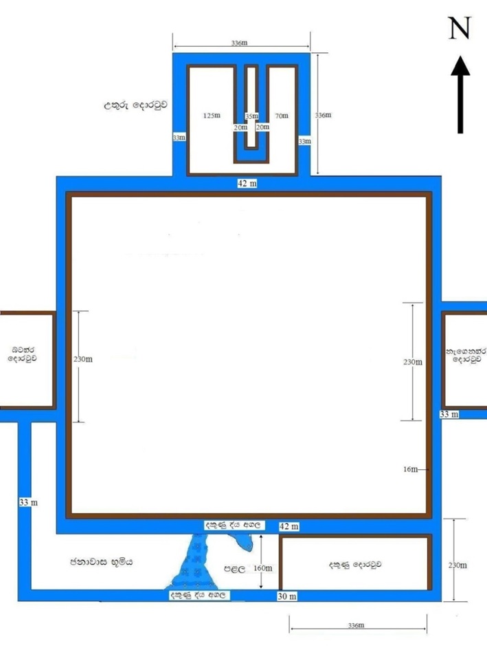
The fortress can be divided into two sections, the main section is a large quadrangle and the other sections are rectangular gateways on the four sides. The length of the southern rampart based on visible and topographic features is approximately 870 meters; with the eastern and western moats, the length of the entire southern section would be 963 meters. The western rampart from north to south is approximately 840 meters and with the northern and southern moats is 922 meters. The outer moat of the south along with residential area is 190 meters wide. In total the entire area covered by the fort is approximately 1,108,032 square meters; 43,813 perches; 273 acres; 110 hectares; and 1.10 square kilometers. In total this fort is spread over a square kilometre of area. The northern gate including the moat is 336 meters in length by 200 meters in width.
The southern side of the fortress appears to have been strongly built indicating the main perception for its construction, mainly targeting the approach path of the enemy which would have been from the south, thus strengthening that particular side. The moat beyond the southern rampart is 42 meters wide and beyond that is a stretch of land 160 meters in width. South of that is another moat 30 meters in width. It is believed that the area beyond the second moat was covered by a lake or a marshland. The 160 meters wide stretch between the two moats is believed to have been a security zone as well as a forward defence zone. This area can be identified as a housing scheme as evident from the pottery pieces, hence it is thought to be the living quarters of the soldiers. The southern gateway appears to have been placed towards the eastern end. Accordingly, the main access route would have been spread on a high ground towards the south where the Mahaweli River and Amban River meet as evidence has shown. When considering the area of the fort, it is equal to the area of the inner city of Anuradhapura but is six times larger than the inner city of Polonnaruwa.
The Rampart
From the main entrance of the Seed production farm, the internal road network that going south and west run on a mound of higher elevation which is the rampart of the fortress. The rampart at its shortest width is 14 meters but can reach to 16 meters at certain places. As an average, it could be taken as 15 meters in width. Due to erosion and harvesting of the fields, noticeable changes could be observed. From Seed production farm office 410 meters of the eastern rampart and 430 meters of the southern rampart function as access roads for the fields.
It was observed that earth has been used in the construction of the ramparts, and the lowest levels of earth appear to have been compressed. The external layers appear to have been made of a mix of crushed stone and earth; this could be the layer dug out during the construction of the moat. The methods used to create these ramparts can be observed from the center section of the south rampart and from certain sections of the north rampart. On the eastern corner of the northern rampart the remaining part is clearly observable. For this, broken long rectangular stones have been used with the earth. The stones found measured 70cm x 15cm x 10 cm. The northern rampart is about 4 meters from the level of the moat (at present from the layer of the paddy fields). The walkway which is 8 meters between the moat and the rampart could clearly be seen. Most likely on top of the earth bund wooden stakes would have been placed forming into watch towers which would have made up the rampart. According to Arthrashasthraya the height of the ramparts should be 36 feet.
The Gates
The main entrance to the fort was situated to the north. The width of the gate is around 200 meters and length around 336 meters. The inner area of this gate comprised of a complex design. The moat surrounding this was connected to the moat surrounding the entire fort and further there were two moats within the center of the gate. West of the gate is a stretch of land 125 meters wide and the moat beyond that running north to south is 20 meters. Another section of land 35 meters wide is surrounded by an inner moat. Built in a way that the moat can be observed from the higher ground, the gateway when approaching from the north from the lake could not be observed clearly due to disorientations created by the moat.
The other gateways are rectangular but not as the northern gate. The longer side of the rectangular gateway is placed along side the fortress. No ramparts can be seen around these, thus could have been surrounded by water or marshes. The eastern gateway can be identified with the area of the present Seed production farm office. Of this only a small area has been built up and the rest is under cultivation. According to vegetation features along the eastern gateway, the western gateway too could be identified; the southern gateway too could be identified through vegetation features and also within this area could be found the remains of a building with stone pillars.
An important feature in the fort is that the gateways are not joined to the fort. The link between the quadrangle of the fort and the gateway is through the moat. It is believed that the link between the gate and the rampart could be easily broken during emergencies. Accordingly, there must have been a draw bridge. The guards would have constantly patrolled the ramparts and there would have been tall watch towers in the four corners of the fort to observe enemy movements from afar.
The moat of the fortress
Around the fort is a moat. The outer moat is 33 meters in width and the rampart was 2 meters above the moat. The moat was covered with water plants such as Lotuses. At the sections still surviving of the moat, the muddy soil suggests it would have been very deep.
At the remaining sections of the moat, paddy fields, banana and kohila plantations and even ponds for exotic fish could be seen at present. The moat between the main fort and the northern and southern gateways is 42 meters wide. From the southern moat, 160 meters from here can be found a second moat 30 meters wide. This goes westwards and then turns northwards. In the area belonging to the Seed production farm this could still be seen.
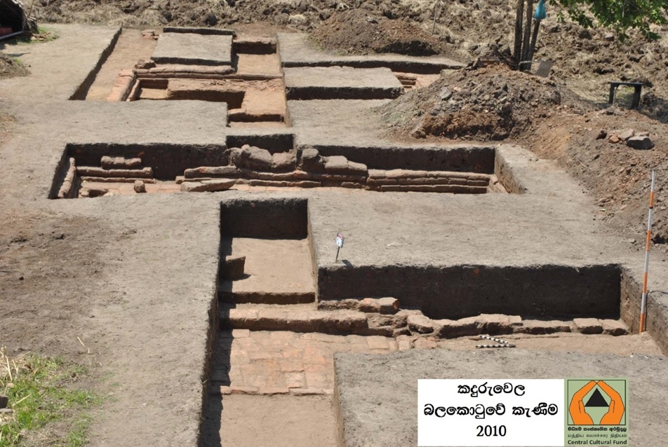
The internal structure of the fort
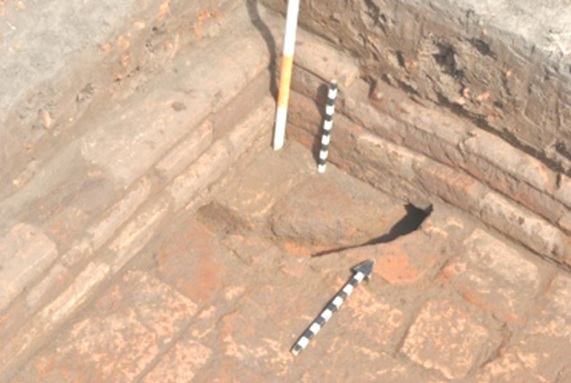
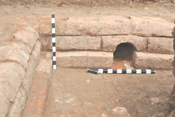
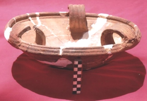
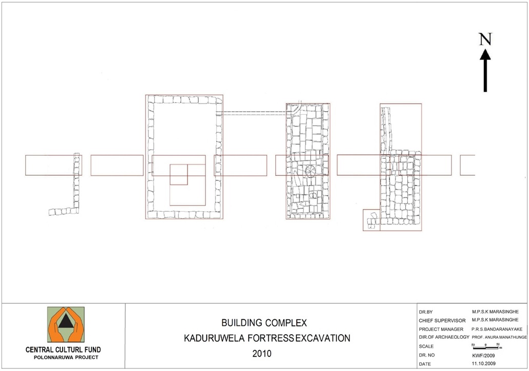
Evidence as to how the internal fort was structured is meager. Half of it has been cultivated by fields and the rest has been built up. However, based on the excavations carried out in 2010, a simple idea can be arrived at as to how this was structured. For the excavation, an area in the paddy fields belonging to the Seed production farm and 100 meters to the center from the southern and western ramparts was selected. This area due to the continuous cultivation had exposed the mound; it was decided to excavate the area where there were lots of bricks and tile pieces which was not cultivatable.
This area was 33 x 10 meters and from the buildings that were exposed, it was clear that the internal buildings were situated according to the four directions. This shows that the internal buildings and streets would have been placed according to a well laid out plan. The excavations revealed an inner courtyard (mada midula) and external bathing area of a house and based on other archaeological artefacts found there, it is believed to be the residence of a high ranking official of the fort.
Are there features of a fort?
When going through the features of the Kaduruwela fort, it is believed to have taken design from the features of fortresses in the ÔÇÿKautilyage ArthrashasthrayaÔÇÖ (ÓÂÜÓÀ×ÓºÓÀÆÓ¢ÓÀèÔÇìÓÂ║Ó£ÓÀÜ ÓÂàÓÂ╗ÓÀèÓ«ÓÀüÓÀÅÓÀâÓÀèÓ¡ÔÇìÓÀèÔÇìÓÂ╗ÓÂ║). According to that a fort should be surrounded by three moats, but in the Kanduruwela fortress this has been done only on the southern side where enemy attacks were expected. On the south are two moats with the lake used as the third moat. These features were designed based on the topographic features of the land and not according to any particular design it is understood.
The method of designing a fortress is given in the Kautilyage Arthrashasthraya: ÔÇ£for the erecting of a fort, the most suitable natural position must be selected. If it is not surrounded by a river, it should be built on a higher elevation with low plains surrounding itÔÇØ. Such features can be seen on the Kanduruwela fort as it is situated on a higher elevation. When turning to the western gateway, it could be seen that the surrounding area is on a considerably lower elevation. Spread throughout this low plains at present are paddy fields fed by the no. 4 canal of the Parakramasamudraya.
The fortified city should be constructed in a circular, square or rectangular form and surrounded by three moats states the Kautilyage Arthrashasthraya. Further the Arthrashasthraya states for the strengthening of the moat, the banks on either side must be made out of granite or bricks with the base made of granite and made in a way that the moat is supplied with water throughout the year along with a mechanism for removing the excess water; and filled in with Lotus flowers and Crocodiles. Above the moat a rampart should be built, the width of which should be twice the height. The base should be compressed upon using Elephants to strengthen it. Poisonous thorn plants should also be planted.
The present bund of the bund is 16.46 meter (54 feet) in width; hence the height would have been 8.23 meters (27 feet). But the Arthrashasthraya says the rampart should be built at a distance of 24 feet from the moat at a height of 36 feet. Accordingly when 24 feet is taken off the complete width, only 28 feet remain. That would be the width of the bund. Therefore the height of the rampart would be 14 feet. There would have been an open area on the rampart used as the walkway. This feature can be seen on the northern rampart where remains are found. The Mahawamsa description mentions an 18 cubits high gateway. This would be approximately 27 feet. Accordingly the width of the rampart should be 52 feet. That is same the same width as with the present bund.
The eastern and southern sides of the fort were completely protected by tanks. It can be thought that the area under water was up to the foot of the rampart. In 1948 a section of the old tank was restored under a new name called Aluth wawe. Accordingly to folk lore it is believed to be the Dana wawe built by Sulu Mugalan or Chula Moggalana (Mahawamsa chapter 41, verse 61). The reason the southern gateway was not placed in the center may be due to the fact that the water from the tank reached up to the southern rampart hence building it on the remaining space available towards the east. Due to these special features it can be clearly identified with the features of a fortress.
Ideas and opinions on Vijithapura.
The idea that the present area known as Vijithapura (Anuradhapura Yugaya, page 58) which is 20 miles south of Mihintale and a bit north of Kalawawe was the site of the ancient Vijithapura fortress has been put forward only by Prof. Sirimal Ranawalla. But the majority of scholars puts Vijithapura to a location in Polonnaruwa; amoung them are Prof. Senerat Paranavitana (University of Ceylon History of Ceylon Vol.I, chapter iii, page 154), Henry Parker (Ancient Ceylon, pp.237-9), Prof. Mangala Ilangasinghe (Lankadeepa, 28.05.2006, Rajakale uthuru muhude navika satan), and Dr. Panditha Kamburupitiye Vanarathana Thero. Taking into consideration the majority opinion, it could be said that Vijithapura was situated in Polonnaruwa, but they have not suggested any specific location. In 1982 Denis Fernando identified the present ruins through satellite imagery and proposed that this could be the Vijithapura fortress.
Several mentions of fortresses and auxiliary cities in Polonnaruwa can be found. Regarding the Vijithapura fortress, this was captured from King Elara by King Dutugamunu and the 25th chapter of the Mahawamsa gives a detailed description. Further, a fortress is mentioned during the reign of King Vijayabahu, where it mentions that the Cholars in fear barricaded the fortress gate and gave battle and that it took 1 › months for the forces of Vijayabahu to capture it (Mahawamsa chapter 58, verse 54). There is no further mention of the fort captured by Vijayabahu.
Later during the reign of King Gajabahu II a fully equipped fortress is mentioned; it is recorded that King Parakramabahu besieged this fortress and after a battle outside, the defeated King Gajabahu locked himself within his fortress and later when it was about to be stormed the emissaries of the city opened up the gates.
During the Polonnaruwa period there were many auxiliary cities close to the main city such as Rajaweshibuganga, Singhapura and amoung them Vijithapura too is mentioned in the chronicles. King Parakramabahu is said to have built a Vihara known as Veluwana in the auxiliary city known as Vijitha.
Conclusion
A satellite imagery survey was carried out in 2009 once again to positively identify this fortress. And accordingly, through the field survey of the area, features of a fortress were clearly identified. Therefore is this the Vijithapura fortress of Elara? The fortress of the Cholars which Vijayabahu conquered? The fortress of Gajabahu? Or is it the auxiliary city named Vijitha of Parakramabahu? No clear conclusion has been arrived at as yet.
One of the main problems is the lack of sufficient research conducted into the fortÔÇÖs dating. During the excavations carried out in 2010, by examining the size of the bricks and technology of the interior buildings it was identified that these belonged to the early Anuradhapura period; the tiles and clay artefacts found too fit to this period and no evidence has been found thus far indicating its use during the Polonnaruwa period. Hence as no design features of the Polonnaruwa period were found, it could be said to belong to the early Anuradhapura period. Therefore the ideas put forward above on Vijithapura, its descriptions in the chronicles and based on the material evidence found, there is a high possibility of this being the Vijithapura fortress.
This excavation was carried out under the supervision of Prof. Manutunga.
Bibliography
- M─ürasiß╣üha, em.p─½.es.k─ô. 2010 kaduruvela balakoß╣¡uva gav─ôß╣úaß╣çaya h─ü pary─ôß╣úaß╣ça k├ªß╣ç─½ma, madhyama saß╣üskß╣øtika aramudala,polonnaruva vy─üpß╣øtiya
- Laß╣ük─ü vi┼øvavidy─ülay─ô laß╣ük─ü itih─üsaya i k─üß╣çß©ìaya iii pari. duß╣¡ug├ªmuß╣çu rajug─ô jayagrahaß╣çaya, senarat paraß╣çavit─üna 1964 vidy─ülaß╣ük─üra mudraß╣ç─ülaya
- Mhala D─½pavaß╣ü┼øaya ,1997 candrad─üsa kahandava ─üracci es goß©ìag─ô
- vaß╣üsatathappak─üsin─½ mah─üvaß╣üsa ß╣¡─½k─üva, 1994, siß╣ühala anuv─üdayatha akuraß╣¡iy─ô amaravaß╣üsa n─ühimi, h─ômacandra dis─ün─üyaka. p─üli h─ü bauddha adhyayana pa┼øc─üt up─üdhi ─üyatanaya vidy─ülaß╣ük─üra mudraß╣ç─ülaya
- Parker,H. Ancient Ceylon,
- Mah─üvaß╣üsaya I, II, 1996 ┼ør─½ sumaß╣ügala himi, hikkaß©ìuv─ô, baß╣¡uvantuß©ì─üv─ô, d─ôvarakkhita, d─½p─ün─½ prak─ü┼øakana, koß©Àam╠åba