A natural earthen mound consisting of a dense scattering of artifacts on its surface has been reported by the Department of Archaeology in the early 2004. This mound called Valamkatuyaya is situated juxtaposed on Bisokotuvavava, an ancient man-made reservoir now in a completely ruined state. This archaeological feature and the mound are at a place on the right bank of the Kuda Oya, one of the feeding streams of the river Walave. The extent of the mound is about 7 acres and its artifact universe extends approximately ¾ of the total surface area of the mound. An excellent preliminary report about the site` has been provided by the Department of Archaeology in the year 2005 including a brief account of the historical context of the location as well.
[fusion_builder_container hundred_percent=”yes” overflow=”visible”][fusion_builder_row][fusion_builder_column type=”1_1″ background_position=”left top” background_color=”” border_size=”” border_color=”” border_style=”solid” spacing=”yes” background_image=”” background_repeat=”no-repeat” padding=”” margin_top=”0px” margin_bottom=”0px” class=”” id=”” animation_type=”” animation_speed=”0.3″ animation_direction=”left” hide_on_mobile=”no” center_content=”no” min_height=”none”]

Valamkatuyaya has been identified as an archaeological site, which bears a great potential to carry out a controlled survey aiming at an objective of resolving the problems associated with the intra-site level surveys.
Besides, Valamkatuyaya is perhaps the only fairly extensive and less disturbed archaeological site that has been identified so far. The site lies in-between the Balangoda and the Rakvana escarpments . This suggests the geographic peculiarity of the location in comparison with other similar sites in the macro environmental context of the south and southeastern Sri Lanka. The other archaeological sites scattered in the immediate surrounding area, such as Pallebadda, Pollamure, Diyahinna Vihara & Kirimakulgolla and Bambaragala bear early Brahmi inscription are early historic Buddhist monastery sites. The closet to Valamkatuyaya is Bambaragala, which contains four cave inscriptions of the late first millennium BCE (Paranavitana 1970:59). This suggests that places like Valamkatuyaya might have been the locations encompassed in the regional settlement network of the area at least since the early historic period. Perhaps there will be another few hitherto unknown sites in the area that could bear similarities with that of Valamkatuyaya. For example, a location called Pussatota that is situated not far from Valamkatuyaya can be cited. It is a mound but the greater part of it had been destroyed by treasure seekers.
In a broader view one can argue that the archaeological sites like Valamkatuyaya, including the above-mentioned inscription bearing sites, may signify the settlement system of the northwestern periphery of the region, which is historically known as ancient Ruhuna.
[/fusion_builder_column][fusion_builder_column type=”1_1″ background_position=”left top” background_color=”” border_size=”” border_color=”” border_style=”solid” spacing=”yes” background_image=”” background_repeat=”no-repeat” padding=”” margin_top=”0px” margin_bottom=”0px” class=”” id=”” animation_type=”” animation_speed=”0.3″ animation_direction=”left” hide_on_mobile=”no” center_content=”no” min_height=”none”]

The objectives of phase I are 4 fold.
1.     Train a group of young archaeologists from different institutions to conduct intra-site level surveys (as a part of the development of institutional and human resources )
2.     Take immediate measures to protect the site (as a response to the requirement of the protection of the total archaeological heritage)
3.     Take (the) scientific steps to record the archaeological content of the surface (as a part of the inventorisation of the site and the movable antiquities )
4.     Organize a participatory program to convince the local people about the cultural heritage potential of their territory as a part of a long-term familiarization project (to fulfill the enhancement of public awareness of the archaeological heritage)
5.     Form a problem oriented research design and create opportunity for theory building to address one of the important issues in the country’s current archaeological field practice
The fieldwork of phase I conducted during the period between 28th August and 28 September – 2006 was completely devoted to document the site both in micro and macro levels. Micro level included a through survey of the site surface to detect the artifact patterning and to asses the diversity of the material cultural along the time and space. Macro level comprised a wider zonal site survey that has been aimed at providing an inter-site level domain to the entire survey project.
Scrutinized objectives
The principle objectives outlined in section 2 was further scrutinized during the fieldwork of phase I aimed at fulfilling the following requirements.
1. Asses the degree of inventions to the site
2. Examine the intra-site artifact patterning
3. Provide a relative chronological framework to site using the analysis of
artifacts
An area of 0.0297 km2 of the mound was selected as a sample fraction for the investigation. This is  29% of the total extent of the site. The selected area has been divided into 4 zones as A, B etc. Two strategies were employed for sampling. Surface of zone ‘C’ and zone ‘D’ were sampled using systematic stratified technique and the
of zone ‘C’ and zone ‘D’ were sampled using systematic stratified technique and the surface of zone ‘A’ and ‘B’ by stratified random technique. Each zone was divided into 10mx10m size fractions and again each fraction divided into 1mx1m units. The surface soil to a depth maximum 5-7 cm was scraped and subjected to dry sieving to collect the artifacts. The weights of the body fragments were measured and the number of pieces of the other artifacts were counted and recorded.
A survey plan of the sampled area of the mound was drawn in 1:650cm scale. The section of the mound and the contour plan of the mound are also provided. The looted sections of the sampled area were recorded according to the depth that damaged the sub-surface.
Optically Enhanced Digital Imagery (OEDI)
This is a photography based recording and mapping system that can be used to record large surfaces which was developed by the PGIAR. It was tested during this field season. And it proved as a very successful technique that facilitates to document every piece of artifact scattered over a large surface area. During the 4 weeks period nearly 3000 digital photographs have been taken to document a surface of 2 acres in extent. Each photograph is a 1x1m digital image of the sampled area. These images will be
digitized and converted into a scaled map. A full detail of this technique is to be included into the final report of phase I.
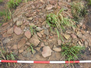
The screening of the shallow depth of the surface of the site reveals a set of diverse artifacts ranging from prehistoric stone implements to late historic earthen wares. The analysis of those artifacts is still in-progress. A brief catalogue of the findings is presented below.
Stone objects
The stone artifacts discovered from the surface are two fold i.e. (1) prehistoric stone implements (quartz) and (2) Grind stones (granite & quartzite) .
Comparatively few prehistoric quartz implements were found from zone ‘C’. The sizes of the grind stones are numerous. The size of the largest example is about 21x30cm.
[/fusion_builder_column][fusion_builder_column type=”1_1″ background_position=”left top” background_color=”” border_size=”” border_color=”” border_style=”solid” spacing=”yes” background_image=”” background_repeat=”no-repeat” padding=”” margin_top=”0px” margin_bottom=”0px” class=”” id=”” animation_type=”” animation_speed=”0.3″ animation_direction=”left” hide_on_mobile=”no” center_content=”no” min_height=”none”]

[/fusion_builder_column][fusion_builder_column type=”1_1″ background_position=”left top” background_color=”” border_size=”” border_color=”” border_style=”solid” spacing=”yes” background_image=”” background_repeat=”no-repeat” padding=”” margin_top=”0px” margin_bottom=”0px” class=”” id=”” animation_type=”” animation_speed=”0.3″ animation_direction=”left” hide_on_mobile=”no” center_content=”no” min_height=”none”]

Metal objects
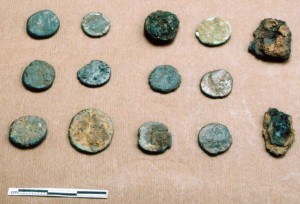
The metal object discovered are confined to a few fragmented iron objects probably pieces of knives and iron nails  and several copper coins. They all are highly deteriorated. The coins seem akin to late roman copper coins. They are found abundantly. For identification, further analysis is needed.
[/fusion_builder_column][fusion_builder_column type=”1_1″ background_position=”left top” background_color=”” border_size=”” border_color=”” border_style=”solid” spacing=”yes” background_image=”” background_repeat=”no-repeat” padding=”” margin_top=”0px” margin_bottom=”0px” class=”” id=”” animation_type=”” animation_speed=”0.3″ animation_direction=”left” hide_on_mobile=”no” center_content=”no” min_height=”none”]

[/fusion_builder_column][fusion_builder_column type=”1_1″ background_position=”left top” background_color=”” border_size=”” border_color=”” border_style=”solid” spacing=”yes” background_image=”” background_repeat=”no-repeat” padding=”” margin_top=”0px” margin_bottom=”0px” class=”” id=”” animation_type=”” animation_speed=”0.3″ animation_direction=”left” hide_on_mobile=”no” center_content=”no” min_height=”none”]

Beads
Total number of beads found is 18. This assemblage comprises 14 terracotta beads, 1 clay bead 1 stone bead and 2 glass beads.
At the present stage we fixed a tentative chronology on the basis of artifacts. But it is highly recommended to establish an absolute dating scheme through a stratified excavation. The relative chronology formulated is as follows.
Phase I – Hunter-gatherer/early agriculture transition exemplified by the evidence of plant processing devises such as the abundance of grind stones together with finely made microliths and the presence of pottery)
Phase II– Early agricultural-pastoral village phase represented by BRW pottery, use of Iron and terracotta circular disk beads)
Phase III– Agricultural-pastoral village and early urban transitive phase represented by relatively sophisticated technology of the terracotta beads and the enhanced quality of the BRW pottery and the relatively extensive use of iron implements)
Phase IV– Urban phase exemplified by the presence of Brahmi letters, imported glass beads and Red polished ware pottery that suggest the links with long-distance trade, presence of punch-marked coins)
Phase V– Urban continuum represented by late roman copper coins and the special pottery such as mica coated ware etc.)
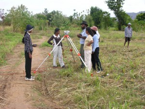
Seven undergraduate students from the Department of History and Archaeology of University of Ruhuna participated in the training. They underwent an intensive training on archaeological field practice including, site assessment, basic surveying, Leveling, surface sampling, site and artifact recording, scale drawing, and GPS reading and plotting.[/fusion_builder_column][/fusion_builder_row][/fusion_builder_container]


